
Thank you for supporting this site ❤️
Make a donation
Make a donation
Koniaków topographic map
Click on the map to display elevation.
Thank you for supporting this site ❤️
Make a donation
Make a donation
Koniaków
Koniaków (Silesian: Kōniakow) is a village in the Beskid Śląski mountain range in Cieszyn County, Silesian Voivodeship, southern Poland. It is the highest village by elevation in the Silesian Beskids and lies in the historical region of Cieszyn Silesia. The village is primarily known for its tradition of intricate lace-making.
Thank you for supporting this site ❤️
Make a donation
Make a donation
About this map
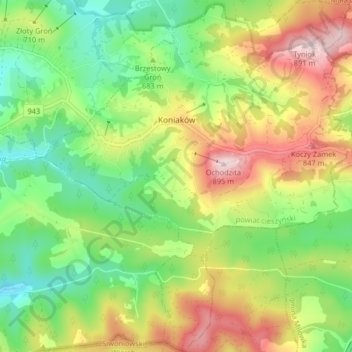
Name: Koniaków topographic map, elevation, terrain.
Average elevation: 683 m
Minimum elevation: 538 m
Maximum elevation: 888 m
Thank you for supporting this site ❤️
Make a donation
Make a donation
Other topographic maps
Click on a map to view its topography, its elevation and its terrain.