

Sauerland topographic map
Click on the map to display elevation.
Sauerland
To the west the hills continue into the Bergisches Land, to the south into the Siegerland, and to the north-east into the Teutoburg Forest. The major rivers of the Sauerland are the Ruhr and the Lenne. Several artificial lakes were created on the smaller rivers by building dams to store water for the nearby Ruhr area, the biggest reservoirs being the Möhne and Bigge. Although the highest elevation of the Sauerland is the Langenberg (843 m) near Olsberg, the much more renowned summit, which is well known for the nearby skiing facilities, its weather station and observation tower, is the slightly lower Kahler Asten (842 m) near Winterberg. Both Langenberg and Kahler Asten are peaks in the Rothaargebirge mountains.
About this map
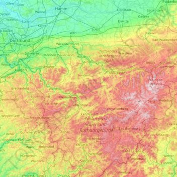
Name: Sauerland topographic map, elevation, terrain.
Location: Sauerland, North Rhine-Westphalia, Germany (50.92129 7.42669 51.59645 8.92098)
Average elevation: 316 m
Minimum elevation: 41 m
Maximum elevation: 844 m
Other topographic maps
Click on a map to view its topography, its elevation and its terrain.
Aachen
Germany > North Rhine-Westphalia > Aachen (district)
The maximum dimensions of the city's territory are 21.6 km (13+3⁄8 mi) from north to south, and 17.2 km (10+3⁄4 mi) from east to west. The city limits are 87.7 km (54+1⁄2 mi) long, of which 23.8 km (14+3⁄4 mi) border Belgium and 21.8 km (13+1⁄2 mi) the Netherlands. The highest point in Aachen,…
Average elevation: 225 m



Bochum
Germany > North Rhine-Westphalia > Bochum
The city lies on the low rolling hills of Bochum land ridge (Bochumer Landrücken), part of the Ruhrhöhen (highest elevations) between the Ruhr and Emscher rivers at the border of the southern and northern Ruhr coal region. The highest point of the city is at Kemnader Straße (Kemnader Street) in Stiepel at…
Average elevation: 107 m
Essen
Germany > North Rhine-Westphalia
The lowest point can be found in the northern borough of Karnap at 26.5 m (86.9 ft), the highest point in the borough of Heidhausen at 202.5 m (664 ft). The average elevation is 116 m (381 ft).
Average elevation: 86 m


Klein-Netterden
Germany > North Rhine-Westphalia > Kreis Kleve > Emmerich on the Rhine
Average elevation: 17 m
Wuppertal
Germany > North Rhine-Westphalia > Wuppertal
Uniquely for Germany, it is a "linear city", owing to the steep hillsides along the river Wupper. Its highest hill is the Lichtscheid, which is 351 metres above sea level. The dominant urban centres Elberfeld (historic commercial centre) and Barmen (more industrial) have formed a continuous urbanized area…
Average elevation: 209 m
Warstein
Germany > North Rhine-Westphalia > Kreis Soest
Warstein is located north of the Arnsberger Wald (forest), at a brook called Wäster. The area south of the city is mostly forested; the lightly forested Haarstrang mountain is to the north. The river Möhne flows between these two areas. The highest elevation is 581 m (1,906 ft) in the south of the city near…
Average elevation: 373 m
Bergisch Gladbach
Germany > North Rhine-Westphalia > Rheinisch-Bergischer Kreis
Average elevation: 115 m
Velbert
Germany > North Rhine-Westphalia > Kreis Mettmann
Velbert stands on the highest part of the Niederberg region and also in its centre. Its average elevation is around 230 metres above sea level; its highest point, at 303 metres, is the Hordt-Berg, and its lowest, at around 70.6 metres, is in Nierenhof am Deilbach. The highest point in Velbert itself is 263…
Average elevation: 172 m
Wuppertal
Germany > North Rhine-Westphalia
Wuppertal is located in the Bergisches Land region of North Rhine-Westphalia. The city is situated in the valley of the Wupper river, which flows through the city from east to west and is a tributary of the Rhine. Wuppertal is characterised by its steep hills and narrow valleys, giving the city a distinctive…
Average elevation: 242 m

Gütersloh
Germany > North Rhine-Westphalia > Kreis Gütersloh
Gütersloh lies in the Emssandebene, south-west of the Teutoburg Forest and on the north-eastern edge of the Westphalian Basin and has no significant points of elevation. The town's lowest point is 64 metres (210 ft) above sea level on the river Ems near the Princess Royal Barracks and the highest point is 105…
Average elevation: 84 m


Dusseldorf
Germany > North Rhine-Westphalia
14 August 1288 is one of the most important dates in the history of Düsseldorf, the day the sovereign Count Adolf VIII of Berg granted town privileges to the village on the banks of the Düssel. Before this, a bloody struggle for power had taken place between the Archbishop of Cologne and his allies arrayed…
Average elevation: 54 m
Winterberg
Germany > North Rhine-Westphalia > Hochsauerlandkreis
Winterberg experiences a humid continental climate (Köppen Dfb) like most of Germany, however also bordering on subarctic climate (Dfc), thanks to its altitude, with only having an average temperature above 10 °C and September only being barely above it. The summers are short and cool, while the winters are…
Average elevation: 628 m

Recklinghausen (Sauerland)
Germany > North Rhine-Westphalia > Hochsauerlandkreis > Sundern
Average elevation: 332 m


Wuppertal
Germany > North Rhine-Westphalia
Wuppertal is located in the Bergisches Land region of North Rhine-Westphalia. The city is situated in the valley of the Wupper river, which flows through the city from east to west and is a tributary of the Rhine. Wuppertal is characterised by its steep hills and narrow valleys, giving the city a distinctive…
Average elevation: 242 m
Dusseldorf
Germany > North Rhine-Westphalia
14 August 1288 is one of the most important dates in the history of Düsseldorf, the day the sovereign Count Adolf VIII of Berg granted town privileges to the village on the banks of the Düssel. Before this, a bloody struggle for power had taken place between the Archbishop of Cologne and his allies arrayed…
Average elevation: 54 m
Werdohl
Germany > North Rhine-Westphalia > Märkischer Kreis
Werdohl is located in the hills of the Sauerland, at a double meander of the river Lenne and its confluent, the Verse. The highest elevation is the Hölzerne Klinke with 448.8m above sea level, the lowest is in valley of Lenne at the boundary to the city Altena with 162m. Werdohl shares borders with…
Average elevation: 332 m



Teutoburg Forest
Germany > North Rhine-Westphalia > Kreis Gütersloh
The highest elevation in the Southern Teutoburg Forest is the Velmerstot (468 m or 1,535 ft) south of Horn-Bad Meinberg. In the Northern Teutoburg Forest the highest elevation is the Dörenberg (331 m or 1,086 ft) north of Bad Iburg.
Average elevation: 105 m
Siegen
Germany > North Rhine-Westphalia > Kreis Siegen-Wittgenstein
The city's total land area is roughly 115 km2 (44 sq mi). Its greatest east-west span is about 12 km (7 mi), and its greatest north-south span is about 12 km (7 mi). City limits are 48 km (30 mi) long. Siegen lies at a median elevation of 290 m (951 ft) above sea level. The city's greatest elevation is the…
Average elevation: 346 m


Oberdalmerscheid
Germany > North Rhine-Westphalia > Kreis Euskirchen > Wolfert
Average elevation: 566 m

Lippe
Germany > North Rhine-Westphalia
The Lippe (German pronunciation: [ˈlɪpə] ) is a river in North Rhine-Westphalia, Germany. It is a right tributary of the Rhine and 220.3 km (136.9 mi) in length with an elevation difference of 125 metres and a catchment area of 4.890 km². The source is located at the edge of the Teutoburg Forest in Bad…
Average elevation: 161 m
Minden
Germany > North Rhine-Westphalia > Kreis Minden-Lübbecke
The Weser leaves the Minden area at its lowest part in the quarter of Leteln, at 40 metres (131 feet), while the highest part is the top of Häverstädter Berg with 272 metres (892 feet), at the edge of the Wiehen Hills in the quarter of Haddenhausen. The altitude of the town is given officially as 42.2 metres…
Average elevation: 60 m

Essen
Germany > North Rhine-Westphalia
The lowest point can be found in the northern borough of Karnap at 26.5 metres (86.9 ft), the highest point in the borough of Heidhausen at 202.5 metres (664 ft). The average elevation is 116 metres (381 ft).
Average elevation: 86 m
Wahnenbusch
Germany > North Rhine-Westphalia > Kreis Heinsberg > Erkelenz > Tenholt
Average elevation: 94 m
Sythen
Germany > North Rhine-Westphalia > Kreis Recklinghausen > Haltern am See
Average elevation: 54 m
Aachen
Germany > North Rhine-Westphalia > Städteregion Aachen
The maximum dimensions of the city's territory are 21.6 km (13+3⁄8 mi) from north to south, and 17.2 km (10+3⁄4 mi) from east to west. The city limits are 87.7 km (54+1⁄2 mi) long, of which 23.8 km (14+3⁄4 mi) border Belgium and 21.8 km (13+1⁄2 mi) the Netherlands. The highest point in Aachen,…
Average elevation: 225 m
Blockhaus
Germany > North Rhine-Westphalia > Oberbergischer Kreis > Reichshof > Windfus
Average elevation: 409 m
Siegen
Germany > North Rhine-Westphalia > Kreis Siegen-Wittgenstein
The city's total land area is roughly 115 km2 (44 sq mi). Its greatest east-west span is about 12 km (7 mi), and its greatest north-south span is about 12 km (7 mi). City limits are 48 km (30 mi) long. Siegen lies at a median elevation of 290 m (951 ft) above sea level. The city's greatest elevation is the…
Average elevation: 346 m