
Drumettaz-Clarafond topographic map
Interactive map
Click on the map to display elevation.
About this map
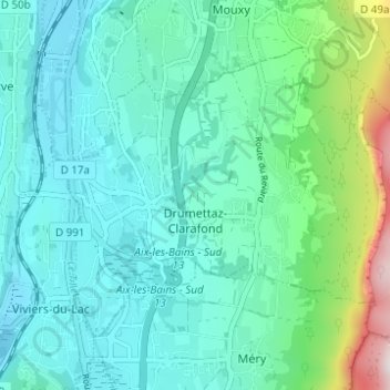
Name: Drumettaz-Clarafond topographic map, elevation, terrain.
Average elevation: 409 m
Minimum elevation: 235 m
Maximum elevation: 1,159 m
La commune de Drumettaz-Clarafond s'étend sur 11,38 km2. Son altitude varie de 257 à 1 513 mètres mais son bourg principal se situe à une altitude d'environ 285 m et la mairie à 390 m.