
Châtel topographic map
Interactive map
Click on the map to display elevation.
About this map
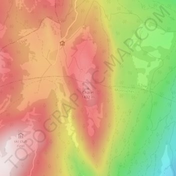
Name: Châtel topographic map, elevation, terrain.
Location: Châtel, Montricher, District de Morges, Vaud, 1147, Suisse (46.62430 6.35536 46.62440 6.35546)
Average elevation: 1,230 m
Minimum elevation: 819 m
Maximum elevation: 1,520 m
Other topographic maps
Click on a map to view its topography, its elevation and its terrain.
Mont Tendre
Suisse > Vaud > District de Morges > Montricher
Mont Tendre, Montricher, District de Morges, Vaud, 1147, Suisse
Average elevation: 1,508 m