
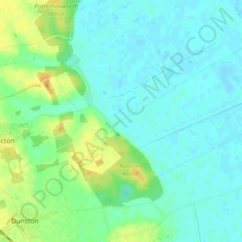
Wasps Nest topographic map
Interactive map
Click on the map to display elevation.
About this map
Name: Wasps Nest topographic map, elevation, terrain.
Average elevation: 8 m
Minimum elevation: -1 m
Maximum elevation: 26 m
Other topographic maps
Click on a map to view its topography, its elevation and its terrain.
Timberland
United Kingdom > England > Lincolnshire > North Kesteven
Timberland, North Kesteven, Lincolnshire, England, LN4 3RX, United Kingdom
Average elevation: 10 m
Digby
United Kingdom > England > Lincolnshire > North Kesteven > Digby
Digby, North Kesteven, Lincolnshire, East Midlands, England, LN4 3YJ, United Kingdom
Average elevation: 17 m
Star Fen
United Kingdom > England > Lincolnshire > North Kesteven
Star Fen, Star Fen Farm, Heckington, North Kesteven, Lincolnshire, East Midlands, England, NG34 9ND, United Kingdom
Average elevation: 4 m
Somerton Castle
United Kingdom > England > Lincolnshire > North Kesteven
Somerton Castle, Boothby Graffoe, North Kesteven, Lincolnshire, East Midlands, England, LN5 0LL, United Kingdom
Average elevation: 13 m