
Somerset County topographic map
Interactive map
Click on the map to display elevation.
About this map
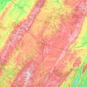
Name: Somerset County topographic map, elevation, terrain.
Location: Somerset County, Pennsylvania, United States of America (39.72137 -79.41778 40.28537 -78.65841)
Average elevation: 632 m
Minimum elevation: 221 m
Maximum elevation: 975 m
Somerset County along with Garrett County is one of the snowiest inhabited locations in the United States, with the highest elevations of the county averaging 150+ inches of snow each winter. The county's elevation and general proximity to both the Great Lakes and the Atlantic Ocean causes snow from both Nor'easters and lake effect upslope snow events to fall from late October through early April. Snow has been recorded in Somerset County in every month except July, although local lore has it that even July saw snow in 1816, "the year without a summer." Mount Davis, the highest natural point in the state of Pennsylvania at 3,213 feet (979 m), is located in the southern part of the County.
Other topographic maps
Click on a map to view its topography, its elevation and its terrain.
Erie County
United States of America > Pennsylvania
Erie County, Pennsylvania, United States of America
Average elevation: 248 m
Julian
United States of America > Pennsylvania > Julian
Julian, Huston Township, Centre County, Pennsylvania, United States of America
Average elevation: 333 m
Delaware County
United States of America > Pennsylvania
Delaware County, Pennsylvania, United States of America
Average elevation: 76 m
Columbia County
United States of America > Pennsylvania
Columbia County, Pennsylvania, United States of America
Average elevation: 306 m
Mercer County
United States of America > Pennsylvania
Mercer County, Pennsylvania, United States of America
Average elevation: 362 m
Shamokin
United States of America > Pennsylvania > Shamokin
Shamokin, Northumberland County, Pennsylvania, United States of America
Average elevation: 282 m
Northumberland County
United States of America > Pennsylvania
Northumberland County, Pennsylvania, United States of America
Average elevation: 250 m
Lehigh County
United States of America > Pennsylvania
Lehigh County, Pennsylvania, United States of America
Average elevation: 186 m
Sullivan County
United States of America > Pennsylvania
Sullivan County, Pennsylvania, United States of America
Average elevation: 491 m
Lackawanna County
United States of America > Pennsylvania
Lackawanna County, Pennsylvania, United States of America
Average elevation: 431 m
Beaver County
United States of America > Pennsylvania
Beaver County, Pennsylvania, United States of America
Average elevation: 325 m
Stroudsburg
United States of America > Pennsylvania > Stroudsburg
Stroudsburg, Monroe County, Pennsylvania, 18360, United States of America
Average elevation: 147 m
Montgomery County
United States of America > Pennsylvania
Montgomery County, Pennsylvania, United States of America
Average elevation: 109 m
Urban
United States of America > Pennsylvania > Urban
Urban, Northumberland County, Pennsylvania, 17830, United States of America
Average elevation: 239 m
Westmoreland County
United States of America > Pennsylvania
Westmoreland County, Pennsylvania, United States of America
Average elevation: 403 m
Philadelphia County
United States of America > Pennsylvania
Philadelphia County, Pennsylvania, United States of America
Average elevation: 39 m