
Village of Addison topographic map
Interactive map
Click on the map to display elevation.
About this map
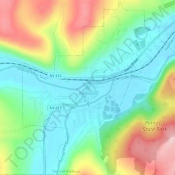
Name: Village of Addison topographic map, elevation, terrain.
Average elevation: 373 m
Minimum elevation: 292 m
Maximum elevation: 521 m
Other topographic maps
Click on a map to view its topography, its elevation and its terrain.
Town of Bath
United States > New York > Steuben County
Town of Bath, Steuben County, New York, United States
Average elevation: 450 m
Town of Wayne
United States > New York > Steuben County
Town of Wayne, Steuben County, New York, 14893, United States
Average elevation: 369 m
City of Corning
United States > New York > Steuben County
City of Corning, Steuben County, New York, United States
Average elevation: 336 m
Town of Wayland
United States > New York > Steuben County
Town of Wayland, Steuben County, New York, United States
Average elevation: 502 m
Marshalls
United States > New York > Steuben County > Town of Wheeler
Marshalls, Town of Wheeler, Steuben County, New York, 14856, United States
Average elevation: 465 m
Town of Bradford
United States > New York > Steuben County
Town of Bradford, Steuben County, New York, United States
Average elevation: 454 m
Town of Hornby
United States > New York > Steuben County
Town of Hornby, Steuben County, New York, 14812, United States
Average elevation: 496 m
Town of Greenwood
United States > New York > Steuben County
Town of Greenwood, Steuben County, New York, 14839, United States
Average elevation: 630 m
Town of Erwin
United States > New York > Steuben County
Town of Erwin, Steuben County, New York, United States
Average elevation: 404 m
Stony Brook State Park
United States > New York > Steuben County
Stony Brook State Park, Town of Dansville, Steuben County, New York, United States
Average elevation: 335 m
Town of Canisteo
United States > New York > Steuben County
Town of Canisteo, Steuben County, New York, 14823, United States
Average elevation: 534 m
Hornby
United States > New York > Steuben County
Hornby, Town of Hornby, Steuben County, New York, United States
Average elevation: 531 m
Painted Post
United States > New York > Steuben County
Painted Post, Town of Erwin, Steuben County, New York, 14870, United States
Average elevation: 332 m
Town of Campbell
United States > New York > Steuben County
Town of Campbell, Steuben County, New York, 14821, United States
Average elevation: 421 m
Risingville
United States > New York > Steuben County > Town of Thurston
Risingville, Town of Thurston, Steuben County, New York, United States
Average elevation: 486 m
Cameron
United States > New York > Steuben County
Cameron, Town of Cameron, Steuben County, New York, 14819, United States
Average elevation: 461 m
Town of Hartsville
United States > New York > Steuben County
Town of Hartsville, Steuben County, New York, United States
Average elevation: 596 m
Village of Avoca
United States > New York > Steuben County > Town of Avoca
Village of Avoca, Town of Avoca, Steuben County, New York, United States
Average elevation: 407 m
Hartsville
United States > New York > Steuben County
Hartsville, Town of Hartsville, Steuben County, New York, United States
Average elevation: 565 m
Atlanta
United States > New York > Steuben County
Atlanta, Town of Cohocton, Steuben County, New York, 14808, United States
Average elevation: 455 m
Pulteney
United States > New York > Steuben County
Pulteney, Town of Pulteney, Steuben County, New York, 14874, United States
Average elevation: 319 m
Troupsburg
United States > New York > Steuben County > Troupsburg
Troupsburg, Town of Troupsburg, Steuben County, New York, 14885, United States
Average elevation: 544 m
Village of Bath
United States > New York > Steuben County > Town of Bath
Village of Bath, Town of Bath, Steuben County, New York, 14810, United States
Average elevation: 371 m
City of Hornell
United States > New York > Steuben County
City of Hornell, Steuben County, New York, 14843, United States
Average elevation: 461 m
Greenwood
United States > New York > Steuben County > Greenwood
Greenwood, Town of Greenwood, Steuben County, New York, 14839, United States
Average elevation: 578 m
Hammondsport
United States > New York > Steuben County > Hammondsport
Hammondsport, Steuben County, New York, United States
Average elevation: 288 m
Campbell
United States > New York > Steuben County > Campbell
Campbell, Town of Campbell, Steuben County, New York, United States
Average elevation: 344 m
Cameron Mills
United States > New York > Steuben County
Cameron Mills, Town of Rathbone, Steuben County, New York, 14820, United States
Average elevation: 430 m