
Grosse Scheidegg topographic map
Interactive map
Click on the map to display elevation.
About this map
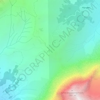
Name: Grosse Scheidegg topographic map, elevation, terrain.
Average elevation: 1,967 m
Minimum elevation: 1,468 m
Maximum elevation: 3,402 m
Other topographic maps
Click on a map to view its topography, its elevation and its terrain.
Eiger
Suisse > Berne > Arrondissement administratif d'Interlaken-Oberhasli > Grindelwald
Eiger, Grindelwald, Arrondissement administratif d'Interlaken-Oberhasli, Région administrative de l'Oberland, Berne, 3818, Suisse
Average elevation: 2,944 m