
Thank you for supporting this site ❤️
Make a donation
Make a donation
Jalpan de Serra topographic map
Click on the map to display elevation.
Thank you for supporting this site ❤️
Make a donation
Make a donation
About this map
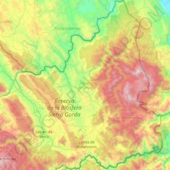
Name: Jalpan de Serra topographic map, elevation, terrain.
Location: Jalpan de Serra, Querétaro, 76340, Mexico (21.09822 -99.54950 21.67001 -99.12240)
Average elevation: 1,137 m
Minimum elevation: 50 m
Maximum elevation: 2,880 m
Thank you for supporting this site ❤️
Make a donation
Make a donation
Other topographic maps
Click on a map to view its topography, its elevation and its terrain.