
Kristen topographic map
Interactive map
Click on the map to display elevation.
About this map
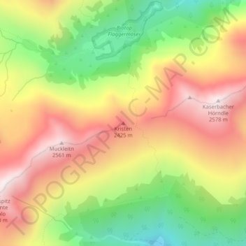
Name: Kristen topographic map, elevation, terrain.
Location: Kristen, Vahrn, Eisacktal, Bozen, Trentino-Südtirol, Italien (46.75377 11.52794 46.75387 11.52804)
Average elevation: 2,181 m
Minimum elevation: 1,767 m
Maximum elevation: 2,570 m
Other topographic maps
Click on a map to view its topography, its elevation and its terrain.
Kühberg (Stangele)
Italien > Trentino-Südtirol > Bozen > Vahrn
Kühberg (Stangele), Vahrn, Eisacktal, Bozen, Trentino-Südtirol, Italien
Average elevation: 2,095 m