
Make a donation
Grosse Pointe Farms topographic map
Click on the map to display elevation.
Make a donation
Grosse Pointe Farms
The Farms has a more varied topography and streetscape than the other southern Grosse Pointes. While Grosse Pointe and Grosse Pointe Park are built on a standard street grid and are basically flat, Grosse Pointe Farms is partially built on the same grid flowing out of Detroit, but also features districts with irregular, curving street paths. A low but noticeable ridge runs through the center of the city. The Farms also contains the "point" in Grosse Pointe, where, just east of the Grosse Pointe War Memorial, there is a large bend in the lakeshore, such that those on the shoreline face east, instead of south, as they do when on the shoreline of neighboring Grosse Pointe, closer to the entrance of the Detroit River.
Make a donation
About this map
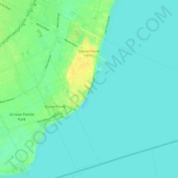
Name: Grosse Pointe Farms topographic map, elevation, terrain.
Average elevation: 177 m
Minimum elevation: 171 m
Maximum elevation: 192 m
Make a donation
Other topographic maps
Click on a map to view its topography, its elevation and its terrain.
Make a donation
Kresge Ford Basement Courtyard
United States > Michigan > Wayne County > Detroit
Average elevation: 193 m
Make a donation
Greenfield Village
United States > Michigan > Wayne County > Greenfield Village
Average elevation: 184 m