
Thank you for supporting this site ❤️
Make a donation
Make a donation
St. Edwards topographic map
Click on the map to display elevation.
Thank you for supporting this site ❤️
Make a donation
Make a donation
About this map
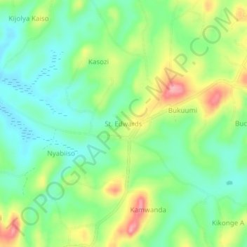
Name: St. Edwards topographic map, elevation, terrain.
Location: St. Edwards, Kakumiro, Western Region, Uganda (0.79660 31.34289 0.83660 31.38289)
Average elevation: 1,281 m
Minimum elevation: 1,236 m
Maximum elevation: 1,357 m
Thank you for supporting this site ❤️
Make a donation
Make a donation