
Holbeach CP topographic map
Interactive map
Click on the map to display elevation.
About this map
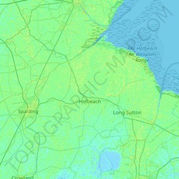
Name: Holbeach CP topographic map, elevation, terrain.
Average elevation: 3 m
Minimum elevation: -2 m
Maximum elevation: 10 m
Other topographic maps
Click on a map to view its topography, its elevation and its terrain.
Whaplode
United Kingdom > England > Lincolnshire > South Holland
Whaplode, South Holland, Lincolnshire, England, PE12 6TG, United Kingdom
Average elevation: 4 m
Sutton St. James
United Kingdom > England > Lincolnshire > South Holland > Sutton St James
Sutton St. James, Sutton St James, South Holland, Lincolnshire, England, United Kingdom
Average elevation: 2 m
Quadring
United Kingdom > England > Lincolnshire > South Holland
Quadring, South Holland, Lincolnshire, England, PE11 4PJ, United Kingdom
Average elevation: 4 m
Crossgate
United Kingdom > England > Lincolnshire > South Holland
Crossgate, South Holland, Lincolnshire, England, PE11 3XS, United Kingdom
Average elevation: 4 m
Surfleet CP
United Kingdom > England > Lincolnshire > South Holland
Surfleet CP, South Holland, Lincolnshire, England, United Kingdom
Average elevation: 4 m
Weston CP
United Kingdom > England > Lincolnshire > South Holland
Weston CP, South Holland, Lincolnshire, England, United Kingdom
Average elevation: 3 m
Gedney Hill
United Kingdom > England > Lincolnshire > South Holland
Gedney Hill, South Holland, Lincolnshire, England, PE12 0NN, United Kingdom
Average elevation: 2 m
Donington CP
United Kingdom > England > Lincolnshire > South Holland
Donington CP, South Holland, Lincolnshire, England, United Kingdom
Average elevation: 3 m
Spalding
United Kingdom > England > Lincolnshire > South Holland
Spalding, South Holland, Lincolnshire, England, PE11 1SR, United Kingdom
Average elevation: 4 m
Moulton
United Kingdom > England > Lincolnshire > South Holland
Moulton, South Holland, Lincolnshire, England, PE12 6GA, United Kingdom
Average elevation: 4 m
West Pinchbeck
United Kingdom > England > Lincolnshire > South Holland > Pinchbeck CP
West Pinchbeck, Pinchbeck CP, South Holland, Lincolnshire, England, PE11 3NH, United Kingdom
Average elevation: 4 m