
Vallée du Rhône topographic map
Interactive map
Click on the map to display elevation.
About this map
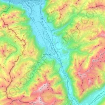
Name: Vallée du Rhône topographic map, elevation, terrain.
Location: Vallée du Rhône, District d'Aigle, Waadland, 1902, Zwitserland (46.11847 6.85834 46.39681 7.06994)
Average elevation: 1,378 m
Minimum elevation: 367 m
Maximum elevation: 3,247 m
Other topographic maps
Click on a map to view its topography, its elevation and its terrain.
Noville
Zwitserland > Waadland > District d'Aigle
Noville, District d'Aigle, Waadland, 1845, Zwitserland
Average elevation: 384 m
Leysin
Zwitserland > Waadland > District d'Aigle
Leysin, District d'Aigle, Waadland, 1854, Zwitserland
Average elevation: 1,352 m
Villars-sur-Ollon
Zwitserland > Waadland > District d'Aigle
Villars-sur-Ollon, Ollon, District d'Aigle, Waadland, 1884, Zwitserland
Average elevation: 1,293 m
Aigle
Zwitserland > Waadland > District d'Aigle
Aigle, District d'Aigle, Waadland, 1860, Zwitserland
Average elevation: 647 m
Gryon
Zwitserland > Waadland > District d'Aigle
Gryon, District d'Aigle, Waadland, 1882, Zwitserland
Average elevation: 1,240 m