
Kiewit topographic map
Interactive map
Click on the map to display elevation.
About this map
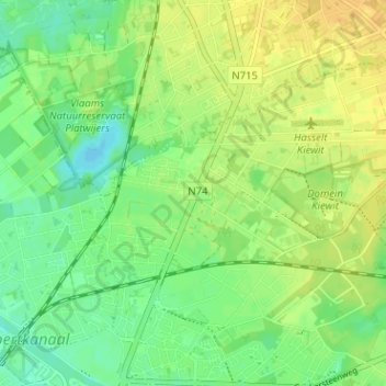
Name: Kiewit topographic map, elevation, terrain.
Location: Kiewit, Hasselt, Limburg, Vlaanderen, 3520, België (50.94317 5.33489 50.98317 5.37489)
Average elevation: 37 m
Minimum elevation: 24 m
Maximum elevation: 48 m
Other topographic maps
Click on a map to view its topography, its elevation and its terrain.
Rapertingen
België > Limburg > Hasselt > Hasselt
Rapertingen, Hasselt, Limburg, Vlaanderen, België
Average elevation: 49 m
Heksenberg
België > Limburg > Hasselt > Hasselt > Heksenberg
Heksenberg, Banneux, Hasselt, Limburg, Vlaanderen, 3500, België
Average elevation: 35 m