
Make a donation
Tamanrasset topographic map
Click on the map to display elevation.
Make a donation
Tamanrasset
It is located in the deep southern region of Algeria and is 2000 km south of Algiers (capital of Algeria). On the north it is bordered by In Salah Province, on the north-east by Illizi Province, on the east by Djanet Province, on the south by In Guezzam Province, and on the west by Adrar Province, the second largest province by area, and Bordj Badji Mokhtar Province. Tamanrasset also has an international border with Niger. The province is the largest Algerian province with area of 336,854 km2 (130,060 sq mi) although it is located in the heart of the desert. The Province of Tamanrasset has a moderate climate because of its mountainous terrain. The province has an elevation of 1,400 meters. The highest point of Tamanrasset Province is Mount Tahat, which is also the highest point of Algeria with 3,303 meters. The most well known tourist destination is the Tomb of Tinhan.
Make a donation
About this map
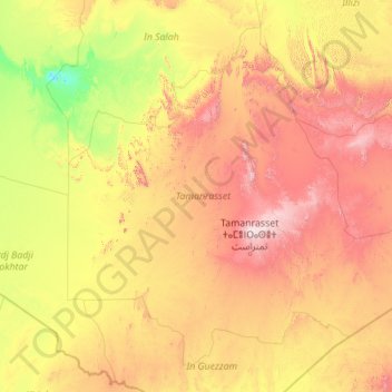
Name: Tamanrasset topographic map, elevation, terrain.
Location: Tamanrasset, Algeria (20.44417 1.41672 27.41243 10.27055)
Average elevation: 641 m
Minimum elevation: 121 m
Maximum elevation: 2,637 m
Make a donation
Other topographic maps
Click on a map to view its topography, its elevation and its terrain.