
Thank you for supporting this site ❤️
Make a donation
Make a donation
Niendorf topographic map
Click on the map to display elevation.
Thank you for supporting this site ❤️
Make a donation
Make a donation
Niendorf
Niendorf liegt am Flüsschen Maurine, ca. 13 km südöstlich von Lübeck. Das hügelige Gebiet um den Ort erreicht Höhen bis zu 50 m ü. NN.
Thank you for supporting this site ❤️
Make a donation
Make a donation
About this map
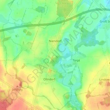
Name: Niendorf topographic map, elevation, terrain.
Average elevation: 30 m
Minimum elevation: 7 m
Maximum elevation: 61 m
Thank you for supporting this site ❤️
Make a donation
Make a donation
Other topographic maps
Click on a map to view its topography, its elevation and its terrain.
Ollndorf
Deutschland > Mecklenburg-Vorpommern > Nordwestmecklenburg > Siemz-Niendorf
Average elevation: 35 m