
Tsageri Municipality topographic map
Interactive map
Click on the map to display elevation.
About this map
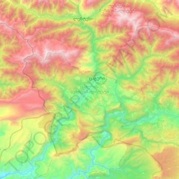
Name: Tsageri Municipality topographic map, elevation, terrain.
Average elevation: 1,304 m
Minimum elevation: 189 m
Maximum elevation: 3,162 m
Other topographic maps
Click on a map to view its topography, its elevation and its terrain.
Shovi
Georgia > Racha-Lechkhumi and Lower Svaneti > Oni Municipality
Shovi, Oni Municipality, Racha-Lechkhumi and Lower Svaneti, Georgia
Average elevation: 1,792 m
Oni, Georgia
Georgia > Racha-Lechkhumi and Lower Svaneti
Oni, Georgia, Racha-Lechkhumi and Lower Svaneti, Georgia
Average elevation: 2,123 m
Ambrolauri
Georgia > Racha-Lechkhumi and Lower Svaneti > Ambrolauri Municipality
Ambrolauri, Ambrolauri Municipality, Racha-Lechkhumi and Lower Svaneti, Georgia
Average elevation: 624 m
Mami
Georgia > Racha-Lechkhumi and Lower Svaneti > Lentekhi Municipality
Mami, Lentekhi Municipality, Racha-Lechkhumi and Lower Svaneti, Georgia
Average elevation: 1,417 m
Oni
Georgia > Racha-Lechkhumi and Lower Svaneti > Oni, Georgia > Oni
Oni, Oni, Georgia, Racha-Lechkhumi and Lower Svaneti, Georgia
Average elevation: 952 m