Geolocate

Whau topographic map

Interactive map

Click on the map to display elevation.

About this map

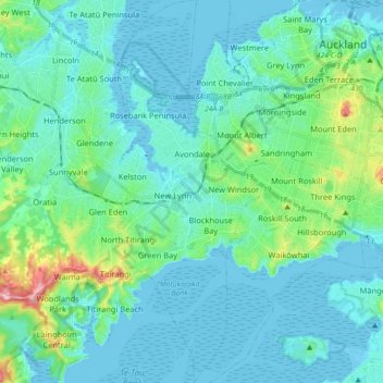
Name: Whau topographic map, elevation, terrain.

Location: Whau, Auckland, 0600, New Zealand (-36.97826 174.64984 -36.83571 174.72440)

Average elevation: 34 m

Minimum elevation: -2 m

Maximum elevation: 221 m

Other topographic maps

Click on a map to view its topography, its elevation and its terrain.

Auckland

New Zealand > Auckland

Auckland, Waitematā, Auckland, 1010, New Zealand

Average elevation: 32 m

Te Kawa Reserve

New Zealand > Auckland > Maungakiekie-Tāmaki

Te Kawa Reserve, One Tree Hill, Maungakiekie-Tāmaki, Auckland, New Zealand

Average elevation: 58 m

Howick

New Zealand > Auckland

Howick, Auckland, New Zealand

Average elevation: 27 m

Rodney

New Zealand > Auckland > Rodney

Rodney, Auckland, New Zealand

Average elevation: 27 m