
Thank you for supporting this site ❤️
Make a donation
Make a donation
Kasserine topographic map
Click on the map to display elevation.
Thank you for supporting this site ❤️
Make a donation
Make a donation
About this map
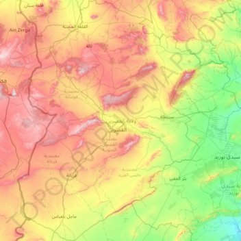
Name: Kasserine topographic map, elevation, terrain.
Location: Kasserine, Tunisia (34.62741 8.24521 35.79092 9.33939)
Average elevation: 710 m
Minimum elevation: 234 m
Maximum elevation: 1,524 m
Thank you for supporting this site ❤️
Make a donation
Make a donation
Other topographic maps
Click on a map to view its topography, its elevation and its terrain.