
Königsforst topographic map
Interactive map
Click on the map to display elevation.
About this map
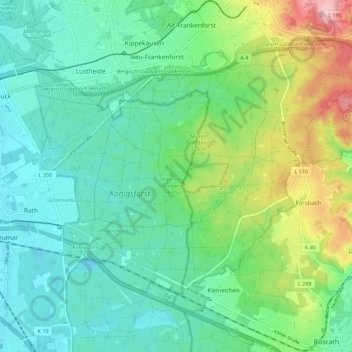
Name: Königsforst topographic map, elevation, terrain.
Average elevation: 95 m
Minimum elevation: 45 m
Maximum elevation: 230 m
Other topographic maps
Click on a map to view its topography, its elevation and its terrain.
Siefen
Deutschland > Nordrhein-Westfalen > Rösrath > Rambrücken > Siefen
Siefen, Rambrücken, Rösrath, Rheinisch-Bergischer Kreis, Nordrhein-Westfalen, 51503, Deutschland
Average elevation: 115 m