
Story County topographic map
Interactive map
Click on the map to display elevation.
About this map
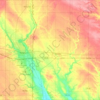
Name: Story County topographic map, elevation, terrain.
Location: Story County, Iowa, United States (41.86279 -93.70002 42.20936 -93.23155)
Average elevation: 308 m
Minimum elevation: 255 m
Maximum elevation: 356 m
Other topographic maps
Click on a map to view its topography, its elevation and its terrain.
Slater
United States > Iowa > Story County
Slater, Story County, Iowa, 50244, United States
Average elevation: 316 m
Kelley
United States > Iowa > Story County
Kelley, Story County, Iowa, United States
Average elevation: 314 m
Ames
United States > Iowa > Story County
Ames, Story County, Iowa, United States
Average elevation: 295 m
Collins
United States > Iowa > Story County
Collins, Story County, Iowa, United States
Average elevation: 305 m
Ames
United States > Iowa > Story County > Ames
Ames, Story County, Iowa, 50010, United States
Average elevation: 308 m