
Getafe topographic map
Interactive map
Click on the map to display elevation.
About this map
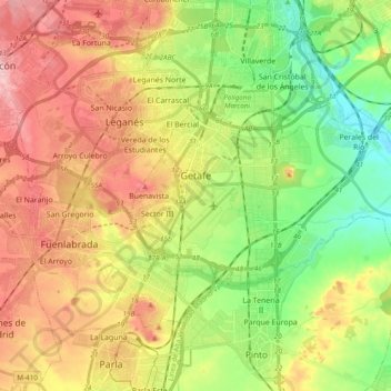
Name: Getafe topographic map, elevation, terrain.
Average elevation: 631 m
Minimum elevation: 549 m
Maximum elevation: 726 m
Other topographic maps
Click on a map to view its topography, its elevation and its terrain.
Sector III (Cerro Buenavista)
España > Comunidad de Madrid > Getafe
Sector III (Cerro Buenavista), Getafe, Área metropolitana de Madrid y Corredor del Henares, Comunidad de Madrid, 28905, España
Average elevation: 645 m