
Thank you for supporting this site ❤️
Make a donation
Make a donation
Sallisaw topographic map
Click on the map to display elevation.
Thank you for supporting this site ❤️
Make a donation
Make a donation
About this map
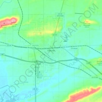
Name: Sallisaw topographic map, elevation, terrain.
Location: Sallisaw, Sequoyah County, Oklahoma, 74955, United States (35.42395 -94.86799 35.49245 -94.75227)
Average elevation: 167 m
Minimum elevation: 139 m
Maximum elevation: 270 m
Thank you for supporting this site ❤️
Make a donation
Make a donation
Other topographic maps
Click on a map to view its topography, its elevation and its terrain.