
Thank you for supporting this site ❤️
Make a donation
Make a donation
Parvenets topographic map
Click on the map to display elevation.
Thank you for supporting this site ❤️
Make a donation
Make a donation
About this map
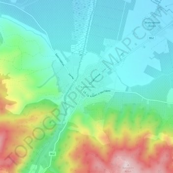
Name: Parvenets topographic map, elevation, terrain.
Location: Parvenets, Rodopi, Plovdiv, 4110, Bulgaria (42.05445 24.64299 42.09445 24.68299)
Average elevation: 290 m
Minimum elevation: 183 m
Maximum elevation: 549 m
Thank you for supporting this site ❤️
Make a donation
Make a donation
Other topographic maps
Click on a map to view its topography, its elevation and its terrain.
Thank you for supporting this site ❤️
Make a donation
Make a donation