
Thank you for supporting this site ❤️
Make a donation
Make a donation
Rosendahl topographic map
Click on the map to display elevation.
Thank you for supporting this site ❤️
Make a donation
Make a donation
About this map
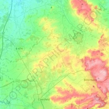
Name: Rosendahl topographic map, elevation, terrain.
Location: Rosendahl, Kreis Coesfeld, Noordrijn-Westfalen, 48720, Duitsland (51.97414 7.04621 52.06223 7.33594)
Average elevation: 95 m
Minimum elevation: 51 m
Maximum elevation: 177 m
Thank you for supporting this site ❤️
Make a donation
Make a donation
Other topographic maps
Click on a map to view its topography, its elevation and its terrain.
Rosendahl
Duitsland > Noordrijn-Westfalen > Kreis Coesfeld > Rosendahl > Rosendahl
Average elevation: 99 m
Thank you for supporting this site ❤️
Make a donation
Make a donation