
Make a donation
Taunggyi topographic map
Click on the map to display elevation.
Make a donation
Taunggyi
Taunggyi (Burmese: တောင်ကြီးမြို့; MLCTS: taung kri: mrui. [tàʊɰ̃dʑí mjo̰]; Shan: ဝဵင်းတူၼ်ႈတီး ဝဵင်းလူင်တႆးႁဝ်း Shan pronunciation: [weŋ˥ ton˧˧˨ ti˥]; Pa'O language : ဝေင်ꩻတောင်ႏကီꩻ is the capital and largest city of Shan State, Myanmar (Burma) ဝဵင်းလူင်မိူင်းတႆး and lies on the Thazi-Kyaingtong road at an elevation of 4,712 feet (1,436 m), just north of Shwenyaung and Inle Lake within the Myelat region. Taunggyi is the fifth largest city of Myanmar, although Taunggyi is the capital of Shan State , 45% of Population are Pa'O people and has an estimated population of 380,665 as of 2014. The city is famous for its hot air balloon festival held annually on the full moon day of Tazaungmon.
Make a donation
About this map
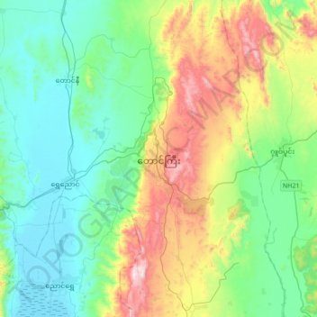
Name: Taunggyi topographic map, elevation, terrain.
Average elevation: 1,151 m
Minimum elevation: 884 m
Maximum elevation: 1,857 m
Make a donation
Other topographic maps
Click on a map to view its topography, its elevation and its terrain.
Make a donation
Pinlaung Township
Myanmar > Shan State > Taunggyi District > Pinlaung Township
Pinlaung Township accounts for the largest area of tea cultivation in southern Shan State. The Tea grown here is of the Assamica cultivar. Tea plantations in the area cover 12,000 acres, with half of the cultivation taking place in the higher elevations of Le Hlaung, 10 miles from Pinlaung. In the Koe Khaung…
Average elevation: 964 m