
Make a donation
Sussex County topographic map
Click on the map to display elevation.
Make a donation
Sussex County
Sussex County, located in the southern part of Delaware, features a predominantly flat terrain characteristic of the Atlantic Coastal Plain. The county's elevation ranges from sea level along the Atlantic Ocean and Delaware Bay to approximately 79 feet (24 meters) above sea level at its highest points. This minimal elevation variation contributes to the region's extensive wetlands, including the Great Cypress Swamp, which harbors the northernmost strand of bald cypress trees in the United States. The county's landscape is further defined by its coastal beaches, inland agricultural fields, and numerous waterways, such as the Broadkill River and the Nanticoke River, which meander through the flat countryside.
Make a donation
About this map
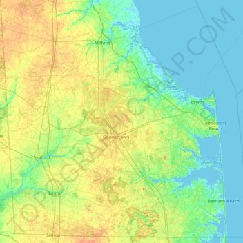
Name: Sussex County topographic map, elevation, terrain.
Location: Sussex County, Delaware, United States (38.45118 -75.72275 39.00081 -74.98494)
Average elevation: 9 m
Minimum elevation: -4 m
Maximum elevation: 24 m
Make a donation
Other topographic maps
Click on a map to view its topography, its elevation and its terrain.
Penn Acres South
United States > Delaware > New Castle County > Wilmington Manor
Average elevation: 12 m
Make a donation
Make a donation
Make a donation
Make a donation
Carousel Park and Equestrian Center
United States > Delaware > New Castle County > Carousel Knoll
Average elevation: 56 m
Make a donation
Cool Spring Reservoir
United States > Delaware > New Castle County > Wilmington
Average elevation: 38 m
Make a donation
Make a donation
Make a donation
Make a donation
Meeting House Meadows
United States > Delaware > New Castle County > Hockessin
Average elevation: 95 m
Make a donation
Make a donation
Quaker Hill
United States > Delaware > New Castle County > Hockessin, Delaware
Average elevation: 94 m
Make a donation
Make a donation
Make a donation
Make a donation
Penn Acres South
United States > Delaware > New Castle County > Wilmington Manor
Average elevation: 12 m
Make a donation
Make a donation
Tree Top Valley
United States > Delaware > New Castle County > Hockessin, Delaware > Tree Top Valley
Average elevation: 93 m
Wilmington
United States > Delaware > New Castle County > Wilmington
On the western side of Market Street, the Piedmont topography is rocky and hilly, rising to a point that marks the watershed between the Brandywine River and the Christina River. This watershed line runs along Delaware Avenue westward from 10th Street and Market Street.
Average elevation: 43 m
Runnymeade
United States > Delaware > New Castle County > Hockessin, Delaware > Runnymeade
Average elevation: 92 m
Make a donation
Make a donation