Geolocate

Jarnac topographic map

Interactive map

Click on the map to display elevation.

About this map

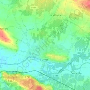
Name: Jarnac topographic map, elevation, terrain.

Location: Jarnac, Cognac, Charente, Nouvelle-Aquitaine, Metropolitan France, 16200, France (45.67207 -0.20767 45.70329 -0.13126)

Average elevation: 24 m

Minimum elevation: 7 m

Maximum elevation: 63 m

Other topographic maps

Click on a map to view its topography, its elevation and its terrain.

Les Gillardes

France > Nouvelle-Aquitaine > Charente > Bioussac

Average elevation: 118 m

Basset

France > Nouvelle-Aquitaine > Charente > Juignac

Average elevation: 144 m

Verina

France > Nouvelle-Aquitaine > Charente > Lesterps

Average elevation: 248 m

Le Maine

France > Nouvelle-Aquitaine > Charente > Champniers

Average elevation: 72 m

La Broue

France > Nouvelle-Aquitaine > Charente > Saint-Gourson

Average elevation: 124 m

Servolles

France > Nouvelle-Aquitaine > Charente > Massignac

Average elevation: 249 m

Les Cossardières

France > Nouvelle-Aquitaine > Charente

Average elevation: 245 m

Pairs

France > Nouvelle-Aquitaine > Charente > Saint-Christophe

Average elevation: 264 m