
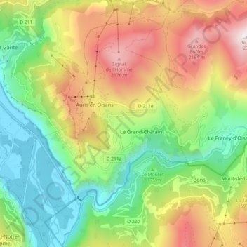
Auris topographic map
Interactive map
Click on the map to display elevation.
About this map
Name: Auris topographic map, elevation, terrain.
Average elevation: 1,380 m
Minimum elevation: 714 m
Maximum elevation: 2,342 m
Other topographic maps
Click on a map to view its topography, its elevation and its terrain.
Saint-Just-Chaleyssin
France > Auvergne-Rhône-Alpes > Isère
Saint-Just-Chaleyssin, Vienne, Isère, Auvergne-Rhône-Alpes, Metropolitan France, 38540, France
Average elevation: 285 m
Chanaix
France > Auvergne-Rhône-Alpes > Isère > Romagnieu
Chanaix, Romagnieu, La Tour-du-Pin, Isère, Auvergne-Rhône-Alpes, Metropolitan France, 38480, France
Average elevation: 247 m
Le Bassey
France > Auvergne-Rhône-Alpes > Isère > Le Bourg-d'Oisans
Le Bassey, Le Bourg-d'Oisans, Grenoble, Isère, Auvergne-Rhône-Alpes, Metropolitan France, 38520, France
Average elevation: 1,061 m
Mizoën
France > Auvergne-Rhône-Alpes > Isère > Mizoën
Mizoën, Grenoble, Isère, Auvergne-Rhône-Alpes, Metropolitan France, 38142, France
Average elevation: 1,598 m
Curtin
France > Auvergne-Rhône-Alpes > Isère > Vézeronce-Curtin
Curtin, Vézeronce-Curtin, La Tour-du-Pin, Isère, Auvergne-Rhône-Alpes, Metropolitan France, 38510, France
Average elevation: 254 m