
Chad Lake topographic map
Interactive map
Click on the map to display elevation.
About this map
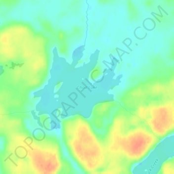
Name: Chad Lake topographic map, elevation, terrain.
Location: Chad Lake, Saint Louis County, Minnesota, USA (47.96637 -92.23489 47.97939 -92.21421)
Average elevation: 441 m
Minimum elevation: 426 m
Maximum elevation: 466 m
Other topographic maps
Click on a map to view its topography, its elevation and its terrain.
Alexandria
USA > Minnesota > Alexandria
Alexandria, Douglas County, Minnesota, 56308, USA
Average elevation: 426 m
Kettle River
Kettle River, Carlton County, Minnesota, 55757, USA
Average elevation: 367 m
Thermal Lake
Thermal Lake, Snowbank Trail, Lake County, Minnesota, USA
Average elevation: 429 m
Prospect Park - East River Road
USA > Minnesota > Minneapolis
Prospect Park - East River Road, Minneapolis, Hennepin County, Minnesota, USA
Average elevation: 260 m
Lake of the Woods County
Lake of the Woods County, Minnesota, USA
Average elevation: 343 m