
Thank you for supporting this site ❤️
Make a donation
Make a donation
Canton El Faro topographic map
Click on the map to display elevation.
Thank you for supporting this site ❤️
Make a donation
Make a donation
About this map
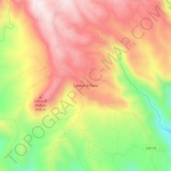
Name: Canton El Faro topographic map, elevation, terrain.
Location: Canton El Faro, Departamento de La Libertad, El Salvador (13.57735 -89.38590 13.61735 -89.34590)
Average elevation: 708 m
Minimum elevation: 370 m
Maximum elevation: 965 m
Thank you for supporting this site ❤️
Make a donation
Make a donation
Other topographic maps
Click on a map to view its topography, its elevation and its terrain.
Thank you for supporting this site ❤️
Make a donation
Make a donation
Cráter El Boqueron del Volcan de San Salvador
El Salvador > Departamento de La Libertad > San Juan Opico > Santa Tecla
Average elevation: 1,658 m
Thank you for supporting this site ❤️
Make a donation
Make a donation
Teotepeque
El Salvador > Departamento de La Libertad > Municipio de Teotepeque
Average elevation: 470 m