
Thank you for supporting this site ❤️
Make a donation
Make a donation
Gaiole in Chianti topographic map
Click on the map to display elevation.
Thank you for supporting this site ❤️
Make a donation
Make a donation
About this map
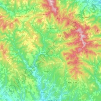
Name: Gaiole in Chianti topographic map, elevation, terrain.
Location: Gaiole in Chianti, Siena, Tuscany, 53013, Italy (43.35530 11.35447 43.51281 11.55176)
Average elevation: 433 m
Minimum elevation: 207 m
Maximum elevation: 837 m
Thank you for supporting this site ❤️
Make a donation
Make a donation
Other topographic maps
Click on a map to view its topography, its elevation and its terrain.
Thank you for supporting this site ❤️
Make a donation
Make a donation
Thank you for supporting this site ❤️
Make a donation
Make a donation
Thank you for supporting this site ❤️
Make a donation
Make a donation