
Make a donation
Deer lake topographic map
Click on the map to display elevation.
Make a donation
About this map
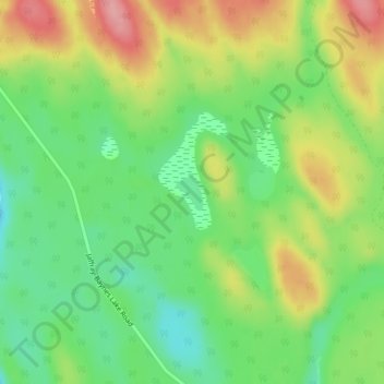
Name: Deer lake topographic map, elevation, terrain.
Average elevation: 811 m
Minimum elevation: 759 m
Maximum elevation: 881 m
Make a donation
Other topographic maps
Click on a map to view its topography, its elevation and its terrain.
Kragmont
Canada > British Columbia > Regional District of East Kootenay > Area B (Lake Koocanusa)
Average elevation: 788 m
Big White Peak
Canada > British Columbia > Regional District of East Kootenay > Area B (Lake Koocanusa)
Average elevation: 1,860 m
Baynes Lake
Canada > British Columbia > Regional District of East Kootenay > Area B (Lake Koocanusa)
Average elevation: 796 m
Gold Creek
Canada > British Columbia > Regional District of East Kootenay > Area B (Lake Koocanusa)
Average elevation: 823 m
Make a donation
Elko
Canada > British Columbia > Regional District of East Kootenay > Area B (Lake Koocanusa)
Average elevation: 1,016 m
Grasmere
Canada > British Columbia > Regional District of East Kootenay > Area B (Lake Koocanusa)
Average elevation: 1,067 m