
Thank you for supporting this site ❤️
Make a donation
Make a donation
Jennings topographic map
Click on the map to display elevation.
Thank you for supporting this site ❤️
Make a donation
Make a donation
Jennings
Jennings is located at 30°13′20″N 92°39′25″W / 30.22222°N 92.65694°W / 30.22222; -92.65694 (30.222207, -92.656880) and has an elevation of 26 feet (7.9 m).
Thank you for supporting this site ❤️
Make a donation
Make a donation
About this map
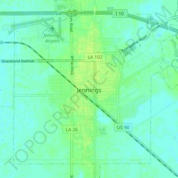
Name: Jennings topographic map, elevation, terrain.
Average elevation: 7 m
Minimum elevation: 2 m
Maximum elevation: 13 m
Thank you for supporting this site ❤️
Make a donation
Make a donation
Other topographic maps
Click on a map to view its topography, its elevation and its terrain.
Jennings
United States > Louisiana > Jefferson Davis Parish > Jennings
Jennings is located at 30°13′20″N 92°39′25″W / 30.22222°N 92.65694°W / 30.22222; -92.65694 (30.222207, -92.656880) and has an elevation of 26 feet (7.9 m).
Average elevation: 6 m