
Thank you for supporting this site ❤️
Make a donation
Make a donation
Buda topographic map
Click on the map to display elevation.
Thank you for supporting this site ❤️
Make a donation
Make a donation
About this map
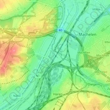
Name: Buda topographic map, elevation, terrain.
Location: Buda, Haren, Bruxelles, Bruxelles-Capitale, 1130, Belgique (50.88519 4.39415 50.92519 4.43415)
Average elevation: 28 m
Minimum elevation: -2 m
Maximum elevation: 75 m
Thank you for supporting this site ❤️
Make a donation
Make a donation
Other topographic maps
Click on a map to view its topography, its elevation and its terrain.