
Kitchener topographic map
Interactive map
Click on the map to display elevation.
About this map
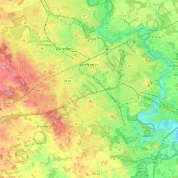
Name: Kitchener topographic map, elevation, terrain.
Average elevation: 336 m
Minimum elevation: 272 m
Maximum elevation: 419 m
Other topographic maps
Click on a map to view its topography, its elevation and its terrain.
Branchton
Canada > Ontario > Region of Waterloo > North Dumfries
Branchton, North Dumfries, Region of Waterloo, Southwestern Ontario, Ontario, N1R 5S2, Canada
Average elevation: 271 m