
Thank you for supporting this site ❤️
Make a donation
Make a donation
Bochum-Ost topographic map
Click on the map to display elevation.
Thank you for supporting this site ❤️
Make a donation
Make a donation
About this map
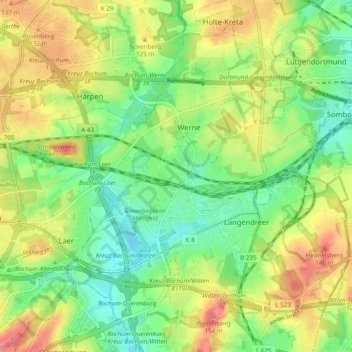
Name: Bochum-Ost topographic map, elevation, terrain.
Location: Bochum-Ost, Bochum, Nordrhein-Westfalen, Deutschland (51.45411 7.25259 51.50602 7.34933)
Average elevation: 111 m
Minimum elevation: 78 m
Maximum elevation: 153 m
Thank you for supporting this site ❤️
Make a donation
Make a donation
Other topographic maps
Click on a map to view its topography, its elevation and its terrain.
Westpark
Deutschland > Nordrhein-Westfalen > Bochum
Die Vergangenheit des Geländes gliedert sich in Schichten. Gebäude- und Anlagenstrukturen bildeten jeweils die Basis einer neuen Schicht, die auf der vorhergehenden aufbaut. Die Schlacken, das Abfallprodukt der Hüttenindustrie und der für die Schwerindustrie erforderliche Massengütertransport trugen zur…
Average elevation: 84 m
Thank you for supporting this site ❤️
Make a donation
Make a donation