
Boussoit topographic map
Interactive map
Click on the map to display elevation.
About this map
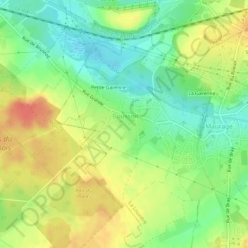
Name: Boussoit topographic map, elevation, terrain.
Location: Boussoit, La Louvière, Henegouwen, Wallonië, 7100, België (50.44885 4.06992 50.46694 4.09303)
Average elevation: 64 m
Minimum elevation: 40 m
Maximum elevation: 91 m
Other topographic maps
Click on a map to view its topography, its elevation and its terrain.
Strépy-Bracquegnies
België > Wallonië > La Louvière > Strépy-Bracquegnies
Strépy-Bracquegnies, La Louvière, Henegouwen, Wallonië, 7110, België
Average elevation: 90 m