
Thank you for supporting this site ❤️
Make a donation
Make a donation
Cerro Punta topographic map
Click on the map to display elevation.
Thank you for supporting this site ❤️
Make a donation
Make a donation
About this map
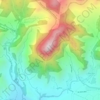
Name: Cerro Punta topographic map, elevation, terrain.
Location: Cerro Punta, Distrito Tierras Altas, Chiriquí, Panamá (8.88001 -82.58550 8.88011 -82.58540)
Average elevation: 2,024 m
Minimum elevation: 1,809 m
Maximum elevation: 2,368 m
Thank you for supporting this site ❤️
Make a donation
Make a donation
Other topographic maps
Click on a map to view its topography, its elevation and its terrain.