
Thank you for supporting this site ❤️
Make a donation
Make a donation
Weener topographic map
Click on the map to display elevation.
Thank you for supporting this site ❤️
Make a donation
Make a donation
About this map
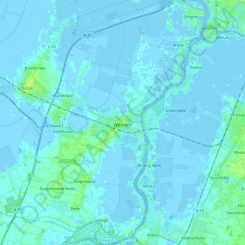
Name: Weener topographic map, elevation, terrain.
Location: Weener, Landkreis Leer, Nedersaksen, 26826, Duitsland (53.10099 7.24623 53.23047 7.41179)
Average elevation: 1 m
Minimum elevation: -6 m
Maximum elevation: 11 m
Thank you for supporting this site ❤️
Make a donation
Make a donation
Other topographic maps
Click on a map to view its topography, its elevation and its terrain.