
Thank you for supporting this site ❤️
Make a donation
Make a donation
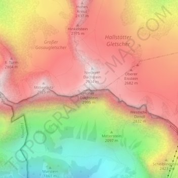
Hoher Dachstein topographic map
Click on the map to display elevation.
Thank you for supporting this site ❤️
Make a donation
Make a donation
Hoher Dachstein
The Dachstein massif covers an area of around 600 square kilometres (230 sq mi) with dozens of peaks above 2,500 m, the highest of which are in the southern and southwestern areas. The main summit of the Hoher Dachstein is at an elevation of 2,997 metres (9,833 ft). Seen from the north, the Dachstein massif is dominated by glaciers with rocky summits rising beyond them. By contrast, to the south, the mountain drops almost vertically to the valley floor.
Thank you for supporting this site ❤️
Make a donation
Make a donation
About this map
Name: Hoher Dachstein topographic map, elevation, terrain.
Average elevation: 2,341 m
Minimum elevation: 1,579 m
Maximum elevation: 2,903 m
Thank you for supporting this site ❤️
Make a donation
Make a donation