
Dalupiri Island topographic map
Interactive map
Click on the map to display elevation.
About this map
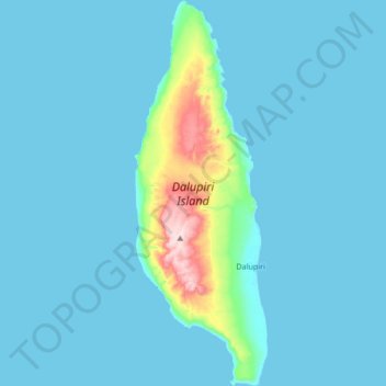
Name: Dalupiri Island topographic map, elevation, terrain.
Average elevation: 25 m
Minimum elevation: 0 m
Maximum elevation: 282 m
Dalupiri Island lies about 45 km (28 mi) north of Luzon and about 15 km (9.3 mi) north of Fuga Island. The island has an elongated elliptical shape orientated along a north–south axis, the island has a length of about 18 km (11 mi), with a width of about 7 km (4.3 mi) at its widest point. The topography of the island is characterized by a flat hilly landscape, in the center of the island, the terrain rises to 297 metres (974 ft) above sea level. The island has an area of 166 square kilometres (64 sq mi). The longest river of the island is the Manolong River, about 2.5 km long.
Other topographic maps
Click on a map to view its topography, its elevation and its terrain.
Babuyan Claro
Philippines > Cagayan > Calayan
Babuyan Claro, Calayan, Cagayan, Cagayan Valley, Philippines
Average elevation: 182 m