
Gunung Samarinda topographic map
Interactive map
Click on the map to display elevation.
About this map
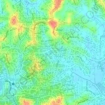
Name: Gunung Samarinda topographic map, elevation, terrain.
Average elevation: 25 m
Minimum elevation: 5 m
Maximum elevation: 65 m
Other topographic maps
Click on a map to view its topography, its elevation and its terrain.
Klandasan Ilir
Indonésie > Kalimantan oriental > Balikpapan
Klandasan Ilir, Balikpapan, Kalimantan oriental, 76121, Indonésie
Average elevation: 17 m