
Le Linleu topographic map
Interactive map
Click on the map to display elevation.
About this map
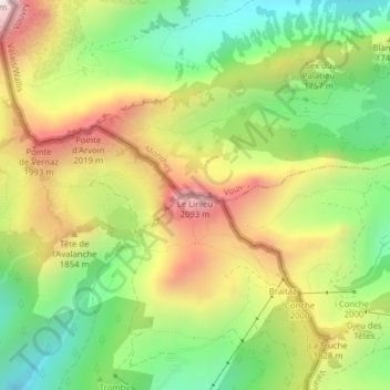
Name: Le Linleu topographic map, elevation, terrain.
Location: Le Linleu, Vouvry, Monthey, Valais, 1896, Suisse (46.31589 6.81687 46.31599 6.81697)
Average elevation: 1,673 m
Minimum elevation: 1,315 m
Maximum elevation: 2,118 m
Other topographic maps
Click on a map to view its topography, its elevation and its terrain.
Les Cornettes de Bise
Les Cornettes de Bise, Vouvry, Monthey, Valais, 1896, Suisse
Average elevation: 1,905 m