
Thank you for supporting this site ❤️
Make a donation
Make a donation
Kakkoor topographic map
Click on the map to display elevation.
Thank you for supporting this site ❤️
Make a donation
Make a donation
About this map
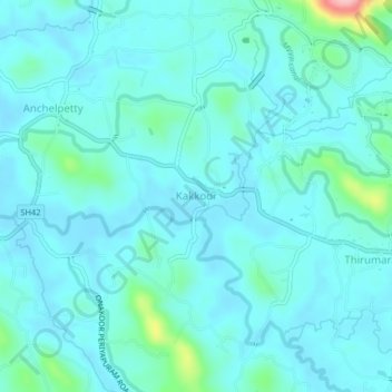
Name: Kakkoor topographic map, elevation, terrain.
Location: Kakkoor, Muvattupuzha, Ernakulam, Kerala, 686667, India (9.87557 76.51149 9.91557 76.55149)
Average elevation: 28 m
Minimum elevation: 7 m
Maximum elevation: 166 m
Thank you for supporting this site ❤️
Make a donation
Make a donation
Other topographic maps
Click on a map to view its topography, its elevation and its terrain.