
Imbabura topographic map
Interactive map
Click on the map to display elevation.
About this map
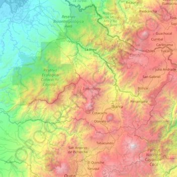
Name: Imbabura topographic map, elevation, terrain.
Location: Imbabura, Ecuador (0.12291 -79.27576 0.87661 -77.81039)
Average elevation: 1,923 m
Minimum elevation: -4 m
Maximum elevation: 5,669 m
Other topographic maps
Click on a map to view its topography, its elevation and its terrain.
Río Amarillo
Río Amarillo, San Miguel de Urcuquí, Imbabura, Ecuador
Average elevation: 1,191 m