
Thank you for supporting this site ❤️
Make a donation
Make a donation
Sigave topographic map
Click on the map to display elevation.
Thank you for supporting this site ❤️
Make a donation
Make a donation
About this map
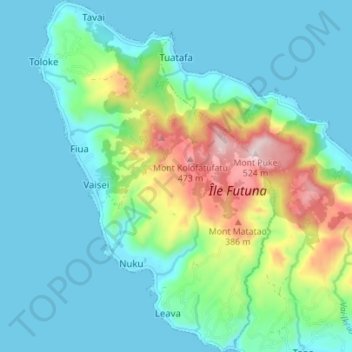
Name: Sigave topographic map, elevation, terrain.
Location: Sigave, Wallis and Futuna, 98620, France (-14.30797 -178.18175 -14.24072 -178.13498)
Average elevation: 115 m
Minimum elevation: -1 m
Maximum elevation: 518 m
Thank you for supporting this site ❤️
Make a donation
Make a donation
Other topographic maps
Click on a map to view its topography, its elevation and its terrain.