
Thank you for supporting this site ❤️
Make a donation
Make a donation
Tumwater topographic map
Click on the map to display elevation.
Thank you for supporting this site ❤️
Make a donation
Make a donation
About this map
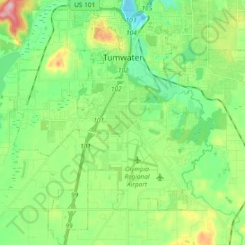
Name: Tumwater topographic map, elevation, terrain.
Average elevation: 58 m
Minimum elevation: -1 m
Maximum elevation: 187 m
Thank you for supporting this site ❤️
Make a donation
Make a donation
Other topographic maps
Click on a map to view its topography, its elevation and its terrain.
Centralia Coal Mine Dam No 32B
United States > Washington > Thurston County > Tono
Average elevation: 104 m
Thank you for supporting this site ❤️
Make a donation
Make a donation
Thank you for supporting this site ❤️
Make a donation
Make a donation