
Thank you for supporting this site ❤️
Make a donation
Make a donation
Phù Mỹ District topographic map
Click on the map to display elevation.
Thank you for supporting this site ❤️
Make a donation
Make a donation
About this map
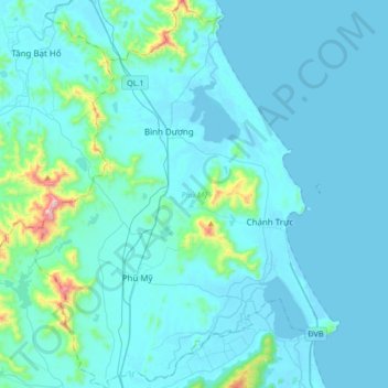
Name: Phù Mỹ District topographic map, elevation, terrain.
Location: Phù Mỹ District, Xã Bình Dương, Gia Lai Province, Vietnam (14.08167 108.96442 14.40708 109.29628)
Average elevation: 63 m
Minimum elevation: -2 m
Maximum elevation: 815 m
Thank you for supporting this site ❤️
Make a donation
Make a donation